
case study
The Tonga volcanic eruption and tsunami
This article provides a case study of the volcano in Tonga, which erupted in January 2022 and was the largest eruption the world had seen in 30 years. GCSE geography courses require you to understand the causes of tectonic hazards and their effects on people and the environment.
On 20 December 2021 a huge submarine volcano in Tonga began to erupt emitting gas, steam and ash. This was followed by more activity on 14 January 2022. Then the following day, Saturday 15 January, at 5 p.m. local time the massive eruption occurred, the biggest the world has experienced since the 1991 Mt Pinatubo eruption in the Philippines.
At the time of writing, scientists have estimated that the eruption rated 6 (out of 8) on the Volcanic Explosivity Index. Incredibly hot magma, over 1,000°C, blasted out and made direct contact with the cool sea water, rapidly turning the water into steam. Fragments of magma were thrown out violently and a tsunami developed which affected locations thousands of kilometres away, such as Peru.
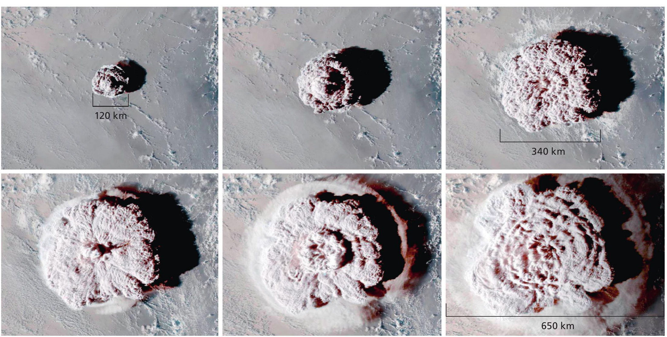
Scientists were shocked by the processes, some saying it was ‘off-thescale weird’ and that ‘it could be a benchmark, a watershed kind of event in volcanology’. The ash cloud was huge — it grew from 38 km wide to 650 km wide within 1 hour, similar to the distance from London to Aberdeen. Scientists also think it is one of the highest ash clouds recorded, as ash from volcanic eruptions is usually trapped in the troposphere, but here it was able to penetrate the stratosphere. The blast was so loud that it could be heard in Alaska and Canada, and it caused atmospheric pressure changes around the world due to the shockwaves that were blasted out at supersonic speeds of 1,000 km per hour. It also sparked 400,000 lightning bolts. Soon after the eruption, tsunami waves up to 15 metres high hit the islands of Tonga and extended as far away as Japan, Hawaii and Peru, over 10,000 km away.
Where is Tonga and what is its tectonic setting?
Tonga is an archipelago of 170 volcanic islands located in the southwest of the Pacific Ocean, 800 km southeast of Fiji and 2,400 km northeast of New Zealand. Its capital, Nuku’alofa, is situated on the main island, Tongatapu.
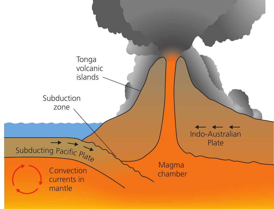
Tonga is located on the so-called Ring of Fire, a series of very active volcanoes forming a horseshoe shape along the plate margins around the Pacific Ocean (see Figure 1). It is situated at a destructive plate margin, where the large oceanic Pacific and Indo-Australian plates meet (see Figure 2), as well as the smaller Tonga plate. Here, Tonga sits in the path of the fastest moving part of the Pacific plate, estimated to be moving westwards at between 15 and 24 cm per year.

Although these are both oceanic plates, the Pacific plate is older and denser, so it is forced under the Indo-Australian plate in the process of subduction (see Figure 2). This creates a long, deep trench, over 1,300 km long and 10 km deep — the second-deepest ocean trench in the world, known as Horizon Deep. Further down, magma slowly escapes to form volcanoes at the bottom of the sea floor. After many eruptions the magma builds up and eventually new land appears above the surface of the sea, forming an island arc — the Tonga islands.
The volcano that erupted in January 2022 was Hunga-Tonga-Hunga-Ha’apai, located 68 km north of the capital, Nuku’alofa. In 2014 there were two separate islands rising 100 m above sea level, Hunga-Ha’apai and Hunga-Tonga. But an eruption in December 2014 led to these two islands merging to create one island, measuring only 1.5 km north to south and 2 km east to west. However, this is just the visible part of the caldera of the volcano. The actual submarine volcano is enormous, rising about 1.8 km from the bottom of the sea. It is 20 km wide and its caldera is 5 km wide. Submarine volcanoes are not unusual as about three quarters of the world’s volcanoes develop under the sea. After the recent eruption most of the island was destroyed, leaving two small islands, once again separated by the Pacific Ocean.
Monitoring the volcano
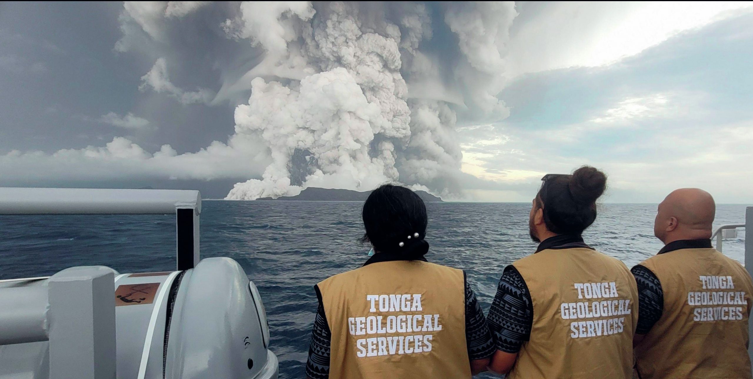
The volcano in Tonga is relatively small and previous eruptions were minor, so scientists at NASA, who have been studying the volcano since 2015 using satellite images, did not expect such a big eruption. The Tonga Geological Services (TGS), a small organisation with few staff, also monitors volcanic activity. This is a challenging task as submarine volcanoes are typically hard to study as research often involves scientists camping out on uninhabited rocky islands. However, in the months and days leading up to the 2022 eruption, a strong sulphur smell was noticeable across Tonga. Furthermore, the water in Nuku’alofa’s harbour was whirling unusually for several days and scientists noticed changes in satellite data. Consequently, the TGS warned locals to stay away from the beaches and this probably saved thousands of lives.
Short term impacts and responses
Impacts
■ 84% of Tonga’s 105,000 population were affected and three people were reported dead.
■ 100 houses were damaged and 50 completely destroyed in Tongatapu.
■ 62 people on Mango, one of the worsthit islands, had to be relocated to the outer island of Nomuka.
■ The sky went dark by 6 p.m., 2 hours earlier than usual, due to the ash cloud.
■ Internet connectivity was lost for 5 days.
■ A layer of ash up to 10 cm deep covered many islands, leaving the land looking grey and dull.
■ In Peru two people drowned due to unusually large waves caused by the tsunami and an oil spill covering 180 hectares of beach.
Immediate responses
■ The Australia and New Zealand governments sent flights to survey the damage because communications were down.
■ Locals and armed forces cleared the runway by hand as equipment had been damaged and it was 4 days before any flights bringing aid could land.
■ International aid workers were not allowed to fly in to give help due to concerns over Covid-19, and specialist aid workers found it difficult to give advice over the phone due to the poor communication signals. Contactless aid drops of supplies, such as water, food, hygiene kits, tents, water-treatment and cable repair equipment, from Australia, New Zealand, USA, China, France, Fiji and the UK, took place. Despite this, Covid-19 spread via port workers, and this prompted a lockdown, which further restricted the distribution of aid.
Conclusion
At the time of writing, scientists are still puzzled about the exact reason why the Tonga eruption was so explosive, and it is too early to tell the longer-term consequences. Around two thirds of families who reared livestock saw their animals die, grazing land damaged or water polluted. There were concerns about the impact on food supplies, potentially leaving islanders relying on imports for many months.
Student activities
1 Explain how a tsunami occurs.
2 ‘Primary effects are more significant than secondary effects’. To what extent do you agree?
Glossary
Archipelago An extensive group of islands scattered across a body of water, such as an ocean.
Destructive margin Where two plates move towards each other, and one is forced underneath the other because it is denser.
Caldera A sunken central section of a volcano, formed where the peak collapsed after a previous eruption.
Contactless aid Aid, such as food supplies, which is dropped from planes or boats without people going inland to help personally.
Island arc A series of islands in the sea in a curved shape, formed when two oceanic plates meet at a destructive margin.
Stratosphere The second layer of the atmosphere, above the troposphere.
Troposphere The lowest part of the atmosphere, reaching up to 15 km high, which contains our weather.


