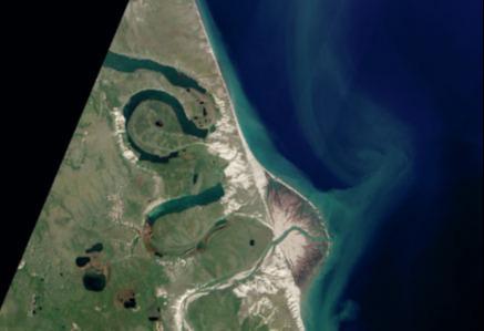
The Horton River flows through a treeless tundra landscape in continuous permafrost in Arctic northwestern Canada. This NASA satellite image was taken on 31 July 2012 when the summer thaw was well underway. It shows the sinuous course of the river on a low-gradient floodplain. The delta is a geologically young feature. The river broke through to the coast to form a new delta sometime after 1640 ad. British explorers mapped this coast in 1826 and recorded the presence of the delta.
This setting illustrates interaction between river and coastal processes and the resulting landscape changes over several centuries. The river migrates across its floodplain forming large elongated, narrow-necked meanders. Several of these meanders are close to becoming cut-offs and several meander bends are very close to the coastline. As the coast eroded and the meanders migrated it was perhaps inevitable — even in the presence of permafrost — that one of the meanders would breach the narrow strip of land and connect with the coast.
Your organisation does not have access to this article.
Sign up today to give your students the edge they need to achieve their best grades with subject expertise
Subscribe


